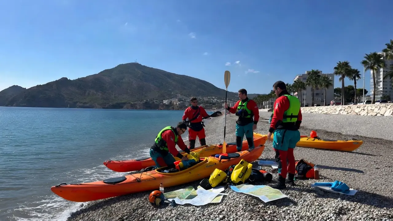
Albir Beach is one of those places where kayaking just makes sense. Paddle a couple of strokes off the shore and the Serra Gelada is already looming in front of you, dropping sheer into the sea, with hidden coves you can only reach by paddling or swimming. You don’t need to be an expert, and you don’t need to bring anything: in summer you can rent a kayak right on the beach, and within ten minutes you’re anchored over a bed of seagrass, watching sea bream drift by beneath the hull.
This page is written for two different kinds of reader. For the visitor who just wants an easy morning on the water: where to rent a kayak, what tours are on offer, and how much they cost. And for the local, or the returning visitor who wants to paddle properly: where to launch from, how the sea behaves depending on the wind, how far you can go, and what rules apply inside the Natural Park. Let’s take it step by step.
Table of Contents
ToggleAlbir Beach, your starting point
Albir Beach isn’t sandy, it’s pebble. That’s the first thing worth knowing, and it’s also why the water is so clear: there’s no sand stirred up to cloud it. It runs about a kilometre long, flies the Blue Flag, and the seabed shelves gently for the first few metres, so getting the kayak in and out is easy. The trade-off is the stones: walking barefoot is miserable, and it’s worse still hauling a loaded kayak. Closed shoes, always.
As a launch point it has a huge advantage over almost any sandy beach in the area: it’s just a few paddle strokes from the most beautiful stretch of the whole coast, the north face of the Serra Gelada. As soon as you round the southern end of the beach, the coastline stops being urban and turns into cliffs and untouched rock. That shift, from seafront promenade to natural park in a matter of minutes’ paddling, is what makes launching from here so special.
[YOUR VOICE: describe exactly where you launch from. The southern end, near the last set of steps? What’s it like getting in first thing, when the sea is calm? This is the kind of local detail no competitor can copy.]
How to get there and where to park
You get here on the N-332, taking the exit for l’Albir. The town is about 50 km from Alicante and very close to Altea and Benidorm. Down by the seafront there’s surface parking, which becomes paid parking in July and August and fills up early. The alternative is to leave the car in the streets further into town, a five- or ten-minute walk away, where you can usually find a free spot almost all year round.
If you’re visiting in high season and want calm water for paddling, the advice cuts both ways: get there before ten in the morning, while parking is still available and before the midday breeze has picked up. Both problems are solved by the same decision: get up a little earlier.
What to bring to launch the kayak
The basic kit for a recreational kayak outing in Albir isn’t complicated, but it’s worth not forgetting anything, because once you’re on the water there’s no easy way back:
- Closed water shoes or reef sandals — essential because of the pebbles on the shore.
- Water, at least a litre per person. The summer sun is strong and there’s no shade out on the water.
- Waterproof sunscreen, a cap, and sunglasses. The glare off the water burns twice as hard.
- A dry bag or waterproof case for your phone and keys. There’s no negotiating this one: your phone will get wet.
- Snorkel mask if you want to look below the surface — in the coves, that’s half the fun.
- A buoyancy aid. I explain why further down — even though it’s not mandatory close to shore, it’s simply the sensible choice.
The coves of the Serra Gelada you can reach by kayak
This is the real reason to kayak in Albir. The north face of the Serra Gelada is a string of rocky, pebble coves that are very hard to reach on foot, but within anyone’s reach by sea if you’re willing to paddle for a while. They’re all inside the Natural Park, so enjoying them also means respecting them. From south to north, as you leave the beach, here are the three main ones.
Amerador Cove
The first and smallest cove, barely twenty metres of arc at the foot of the Morro del Metge, almost right at the entrance to the park. The name comes from the old practice of soaking esparto grass — “amerar” — in its waters. You reach it within a few minutes from the southern end of the beach, and it’s a good first stop to get a feel for the rocks before carrying on. Being so small, it fills up fast if there are a lot of people around, but early in the morning it’s usually all yours.
Cala del Metge
Cala del Metge, or the Doctor’s Cove, is the best known of Albir’s coves and the natural destination for a first outing. The bottom is rock and pebble, the water shallow with patches of seagrass, and it faces northeast, which shelters it from southerly winds. By kayak or paddleboard you’re there in five or ten minutes from the beach. It’s the perfect spot to anchor for a while, slip into the water with a mask, and take in the seabed without ever straying far from the coast.
[YOUR VOICE: what have you seen diving at Metge? Shoals of which fish, at what depth, and what time of year is visibility best? A couple of sentences from your own first-hand experience are worth more than any technical rundown.]
Cala de la Mina
The third and most ambitious of the three. It sits at the foot of the Faralló de la Serra Gelada, close to the lighthouse, and it’s about two kilometres from Albir beach, hugging the mountain the whole way. It takes its name from the old ochre mines nearby. The seabed is rocky and full of life — sea bream, groupers, the odd octopus, starfish — and it’s an anchorage for boats, which moor here on eco-friendly buoys to avoid damaging the bottom. Kayaking to La Mina and back is a proper row, not a stroll; it’s best done with a calm sea, and knowing there are no shortcuts if the wind turns.
[YOUR VOICE: have you paddled to La Mina yourself? How long does it take at an easy pace, what’s the sea like along that stretch hugging the cliff, is there a point where the wind suddenly picks up? This is information only someone who’s actually done it can give.]
Longer paddles: toward Altea and toward Benidorm
For those who already have some stamina and want more, Albir makes a good base camp in both directions. Heading south, rounding Punta del Cavall beneath the tallest cliffs, you reach Illa Mitjana — known as the octopus island, roughly halfway to Benidorm — and the coves of Tío Ximo and Almadrava. Watch out with Illa Mitjana: it’s a bird nesting area and landing there is prohibited. Heading north, the paddle is gentler, with the sheltered bay of Altea and the Isla de la Olla as your landmarks. The full crossing along the outer face of the Serra Gelada, from Altea to Benidorm, is a route for experienced kayakers only, and only in good sea conditions, since along that whole stretch of cliff there’s no safe place to land if you need shelter.
The Serra Gelada offers a lot more than a kayak trip: if you’d also like to explore the park on foot, we have a guide to the mountain and its hiking routes.
Renting a kayak in Albir
If you’re coming without your own gear, the easiest option is to rent right on the beach. The one launching directly from Albir is Marinalia, which runs kayak rentals with equipment pickup just a few minutes’ walk from the sand. The pass includes a life vest, lockers, and showers, and the activity only runs in season, roughly from June to October. You book online and then arrange the time by phone. Prices run around thirty euros for the pass depending on duration, but it’s worth confirming directly on their website before you go, since seasonal rates change.
Very close by, in Altea, there are two well-established options for renting on your own:
- Kayak Club Altea, at Porto Senso (Playa de la Olla). A well-established operator, running since 2006. A double kayak rental runs around €35 for one hour, €45 for two hours, and €50 for three hours, with paddle, life vest, and insurance included. Rates are per kayak, not per person.
- Motos de Agua Altea, at Marina Greenwich (Campomanes). Self-guided rental with rates published on their website: a single kayak around €25 an hour, a double around €30, and a triple around €40, with discounts for extending to two or three hours.
All these prices are approximate and seasonal; common sense says to confirm them on each company’s website before relying on them, since they vary from year to year.
Guided tours with snorkelling
If you’d rather go with an instructor, learn proper technique, or simply have someone take you to the best spots without having to think about it, a guided tour is the way to go. Most of them leave from Benidorm or Altea rather than from Albir itself, but they cover the same stretch of the Serra Gelada coast.
The best-known operator is Capitán Kayak, which departs from the beach by the Club Náutico in Benidorm. They offer several routes: a roughly two-and-a-half-hour loop around the bay and coastline, a couple-of-mile crossing to Benidorm Island, and a longer, four-hour route to Illa Mitjana along the Serra Gelada — this last one only if the sea cooperates. The tours include a certified instructor, all the gear, insurance, and photos of the trip. Indicative prices found on booking platforms run from around €40–45 per person for the bay route to around €60 for the island crossing; the longer Serra Gelada route has no published price and needs to be checked directly.
There are also kayak-and-snorkel excursions that leave straight from Albir beach and can be booked in advance; you can check availability and pricing for the Serra Gelada tour here. As with everything else, confirm the meeting point and time when you book, since they change with the season.
Sea conditions: wind, swell, and the best time of year
The Mediterranean here is treacherous precisely because it looks so calm. It can be flat as a plate at nine in the morning and choppy by one in the afternoon. The key is the two prevailing winds. The Levante, blowing from the east, is the one that whips up swell and hits hard: when the Levante is strong, the cliff face of the Serra Gelada turns nasty and it’s not a place to be without somewhere to shelter. The Poniente, from the west, is drier and generally leaves the sea more manageable in this bay. The bays of Albir and Altea are relatively sheltered from southerly winds, and the northeast-facing coves are protected by the sheer bulk of the mountain itself.
The golden rule is to paddle early in the morning, when the sea tends to be flattest and underwater visibility is best. As for the season, the water sits around 26–27°C in August and stays warm well into autumn, with October still hovering around 24°C. For kayaking, spring and autumn are arguably the best: good weather, warm water, and far fewer people than in the height of summer. And always, the evening before, check the wind and swell forecast — AEMET, Windfinder, or similar — so you’re not caught off guard.
[YOUR VOICE: you live this all year round. What’s your favourite time to paddle here, and why? Is there a month people don’t expect that turns out to be wonderful? That kind of local insight is gold.]
What you can and can’t do
Paddling in Albir is free and easy, but it takes place inside a protected natural park, under navigation rules that are worth knowing. Not to make things complicated, but because they’re what keeps things the way they are.
General navigation rules
A motorless kayak is classed as a floating or beach device under Spanish recreational-craft regulations, so it doesn’t need a licence or registration to be used close to shore. An approved life vest becomes a legal requirement beyond two nautical miles from the coast; closer in, the law doesn’t require it outright, but every activity-tourism company hands one out anyway, and wearing it is simply the sensible thing to do. Out on the water, there’s no room for “it’ll be fine”.
The other key rule concerns swimming areas. On beaches, a two-hundred-metre strip from the shore is reserved for swimmers, where boats can’t exceed three knots and must enter and leave perpendicular to the coast. And of course, you don’t paddle inside the zones marked off with yellow buoys. If you’re ever unsure about the specific rules for a stretch of coast, the Capitanía Marítima (Harbour Authority) is the reference to check.
Rules of the Serra Gelada Natural Park
The Serra Gelada and its coastline have been a natural park since 2005, and it’s the only combined land-and-sea park in the Valencian Community. That comes with a few specific rules for anyone heading into its waters. In the areas of special marine protection, the maximum speed is three knots, rising to twelve knots in the rest of the park. You can’t anchor outside the eco-friendly buoys installed for that purpose, and never over the seagrass meadows, which are a protected habitat. Access to Illa Mitjana and Illot de Benidorm is restricted, and landing on them is not allowed. These are easy rules to follow, and they all point to the same goal: making sure the seabed and the birds are still there next year.
What you’ll see: seabed, seagrass, and cliffs
A good part of what makes paddling here unforgettable isn’t on the surface — it’s below and above it. Under the kayak, the seabed alternates meadows of Posidonia oceanica — that endemic Mediterranean seagrass, protected, which produces oxygen and shelters fish — with walls of vertical rock covered in red gorgonian coral. Among these habitats you’ll spot red mullet, sea bream, groupers, cuttlefish, octopuses and starfish, and with luck even a fan mussel, the large protected mollusc that is now critically endangered. On calm days visibility easily exceeds ten or fifteen metres, so you often don’t even need to dive in to see the bottom from the kayak.
And then there’s what lies above. The cliffs of the Serra Gelada rise over three hundred metres and are among the highest in the Mediterranean, crowned by a fossil dune considered one of the finest in Europe. Peregrine falcons, shags, Audouin’s gulls and the European storm petrel — the smallest of the Mediterranean’s seabirds, which breeds on Illa Mitjana — all nest on these walls. A stable population of common bottlenose dolphins also lives in the park’s waters. Paddling close to that rock face, with birds coming and going from the ledges and the turquoise water below, is one of those experiences that justify the trip to Albir all on its own.
A perfect day: kayak, lighthouse and snorkel
If you want to make the most of the day, the combination that works best is a simple one. Save the kayak for first thing in the morning, when the sea is calm, and spend the morning paddling out to the coves of El Metge or La Mina, anchoring to snorkel wherever the seabed calls for it. By mid-morning, once the breeze picks up and the water gets choppy, it’s a good time to head back to shore.
In the afternoon, back on dry land, the natural way to round things off is the walk to the Faro del Albir, a comfortable, paved path two and a half kilometres long inside the same park, with viewpoints over the whole coastline you paddled that morning. Seeing from above the coves you’ve just explored by kayak gives it all a different dimension.
And if it’s the underwater world that’s hooked you more than the paddling, we’ve put together a snorkel guide to Albir with the best spots to get in the water with your mask and fins.
Kayaking is just one of the many things you can do here. If you’re planning your visit, take a look at everything else in our guide to what to do in El Albir.
And to get to know the town properly before you come, we have our own corner dedicated to El Albir: someone who’s lived here for twenty years tells you what doesn’t make it into the usual guides.

