
Table of Contents
ToggleROUTES AND DAY TRIPS FROM EL ALBIR | DISCOVER & EXPLORE ON FOOT
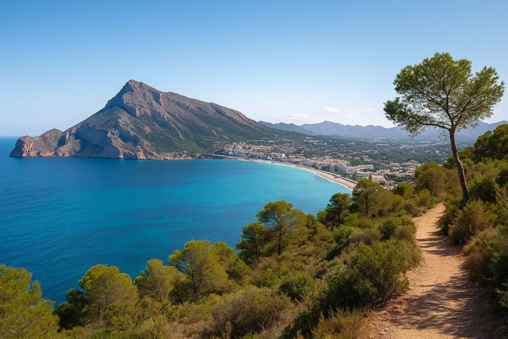
El Albir is much more than a quiet beach on the Costa Blanca. Its location between the Mediterranean Sea and the Serra Gelada Natural Park makes it a strategic base for discovering hiking trails, hidden coves, spectacular viewpoints, and charming towns just minutes away.
From easy walks for families—like the route to the Albir Lighthouse—to more complete excursions through mountains, untouched coves, or escapes to unique places such as Altea, Polop, or Guadalest, the surroundings of El Albir offer plans for every taste and level.
In this updated guide, we show you the best routes, excursions, and charming places near El Albir, with practical information, local tips, and real recommendations to help you make the most of your stay—whether you’re visiting for a few days or thinking about living here.
ROUTES AND NATURE NEAR EL ALBIR
Full Serra Gelada Traverse (Albir – Benidorm)
The Serra Gelada is the great natural backbone that embraces El Albir and separates it from the wild Mediterranean coastline. While most visitors stick to the well-known lighthouse route, the full Serra Gelada traverse is a much more powerful experience—designed for those seeking real hiking and truly impressive landscapes.
This route follows the ridge of the mountain range, connecting El Albir with Benidorm, offering constant views of vertical cliffs, open sea, and an endless coastline. Unlike the lighthouse path, the terrain here is more irregular and exposed to sun and wind, so it is recommended only for hikers with some experience.
Quick facts
- Route type: Linear traverse
- Difficulty: Medium / High
- Duration: 4–5 hours
- Distance: 8–9 km (depending on variation)
- Elevation gain: Moderate
- Start: El Albir (Serra Gelada area)
- Finish: Benidorm (Cruz de Benidorm or Rincón de Loix area)
What makes this route special
- Aerial views of the Mediterranean throughout most of the route
- A strong sense of isolation and wild nature despite being close to urban areas
- Dramatic contrast between peaceful El Albir and Benidorm’s skyline at the end
- Authentic mountain trails far from tourist promenades
Important tips
- Wear proper hiking shoes with good grip (loose rocks and uneven terrain)
- Bring plenty of water—especially in summer (no fountains along the route)
- Avoid midday hours during hot months
- Plan your return from Benidorm (bus, taxi, or pre-arranged car)
If you’re looking for something easier or traveling with children, the Albir Lighthouse route is a much more accessible and family-friendly option.
📍 View on Google Maps
Forat de Bèrnia Route (a must-do excursion from El Albir)
The Forat de Bèrnia route is one of the most spectacular and unique mountain excursions in the province of Alicante, and one of the most recommended if you’re staying in El Albir and want a full day of nature and adventure.
The highlight is the Forat de Bèrnia, a natural tunnel carved through the rock that connects both sides of the mountain. As you cross it, the landscape changes completely—revealing breathtaking views of the Mediterranean coastline, Marina Baixa, and the inland mountains.
The route is circular, offering varied scenery throughout, combining mountain paths, rocky sections, and easier stretches. Its difficulty is moderate, making it suitable for people with a basic level of fitness, but not recommended for young children.
Quick facts
- Route type: Circular
- Difficulty: Medium
- Duration: 3–4 hours
- Distance: 8–9 km
- Elevation gain: Moderate
- Area: Serra de Bèrnia (Altea / Xaló)
- Distance from El Albir: ~30 minutes by car
Why it’s special
- The passage through the Forat—one of the most photogenic spots in Alicante
- Constant landscape changes between north and south sides
- Open views of both the sea and inland mountains
- Adventure feel without being extreme
Practical tips
- Wear hiking shoes (rocky and slippery access to the tunnel)
- Bring a flashlight or headlamp to cross safely
- Avoid rainy or humid days (rock can be very polished and slippery)
- Best in spring and autumn; in summer, start early
👉 If you prefer closer and easier routes, you can combine this excursion with options like the Albir Lighthouse route or Serra Gelada coves—perfect for half a day.
📍 View on Google Maps
Puig Campana Ascent (Finestrat) – the great peak of Marina Baixa
At 1,410 meters, Puig Campana is the second-highest mountain in Alicante and one of the most iconic climbs in the Costa Blanca interior. Its unmistakable silhouette dominates the landscape and is visible from El Albir on clear days.
This is not just another hike—it’s a demanding ascent, designed for experienced hikers in good physical condition. The climb is steady and sometimes tough, but the reward at the summit is hard to match: 360º panoramic views covering the Mediterranean, Serra Gelada, Marina Baixa, and even Ibiza on clear days.
Quick facts
- Maximum elevation: 1,410 m
- Route type: Circular or linear (depending on variation)
- Difficulty: High
- Duration: 5–6 hours
- Elevation gain: High
- Area: Finestrat
- Distance from El Albir: ~25 minutes by car
What makes it special
- One of the most iconic peaks in Alicante
- True high-mountain feeling, rare on the Costa Blanca
- Complete panoramic views of coast and inland mountains
- Several routes for different levels (all demanding)
Important tips
- Only recommended for experienced hikers
- Proper gear, water, and sun protection are essential
- Avoid extreme heat or strong winds
- Check weather forecast before heading out
- In winter, temperatures at the summit can be very low
Peñón de Ifach Natural Park (Calpe) – the vertical icon of the Costa Blanca
The Peñón de Ifach, rising 332 meters above the sea, is one of the most recognizable landmarks on the Costa Blanca and a must-do excursion if you’re staying in El Albir.
The ascent is short but intense. The first section is easy and well-prepared, but after passing through a tunnel, the route becomes more demanding, with chains and uneven terrain. Not a via ferrata, but it requires attention and proper footwear.
Quick facts
- Height: 332 m
- Route type: Out and back
- Difficulty: Medium
- Duration: 2–3 hours
- Area: Calpe
- Distance from El Albir: ~25 minutes by car
Why it’s worth it
- Panoramic views of Calpe and surrounding coastline
- Adventure feel in a protected natural environment
- Unique contrast between sea, rock, and city
Important info
- Reservation required for upper section in high season
- Not recommended for people with vertigo
- Avoid flip-flops or flat shoes
- Dangerous in rain or strong wind
Marjal de Pego-Oliva Natural Park – calm nature and family plans
A completely different landscape: wetlands, rice fields, freshwater channels, and flat paths—perfect for relaxed walks, cycling, and birdwatching.
Quick facts
- Environment: Protected wetland
- Difficulty: Very low
- Ideal for: Families, cycling, birdwatching
- Distance from El Albir: ~45 minutes
Highlights
- Rich biodiversity
- Peaceful, uncrowded environment
- Perfect for slow-paced nature experiences
NATURE EXPERIENCES
Albir Lighthouse Walk (family-friendly)
A fully paved, accessible route with stunning views—perfect for everyone.
- Duration: 1.5–2 hours
- Difficulty: Very low
- Accessible for strollers and reduced mobility
Best enjoyed early morning or at sunset.
Hidden coves near El Albir
Wild, natural, and without services—this is their charm.
- Cala del Metge – great for snorkeling
- Cala de la Mina – isolated and photogenic
- Cala de Ti Ximo – easier access
- Racó del Corb – spectacular but harder access
👉 Bring water, proper footwear, and respect the environment.
Viewpoints around El Albir
- Benidorm Cross viewpoint – iconic panoramic views
- Altea viewpoints – romantic and photogenic
- Serra de Bèrnia viewpoints – wild and less crowded
Best light: sunset.
Wildlife watching
Best spots:
- Serra Gelada – birds of prey and marine birds
- Marjal de Pego-Oliva – aquatic and migratory birds
👉 Move quietly, bring binoculars, respect wildlife.
OUTDOOR ACTIVITIES
Cycling routes
- Altea–Calpe Greenway – easy and scenic
- Albir–Polop–Callosa – mixed landscapes
- Aitana mountains – demanding routes
Water sports
- Kayak – explore cliffs and caves
- Paddle surf – calm and accessible
- Snorkeling – clear waters and marine life
Landscape photography
Perfect mix of:
- Sea
- Mountains
- Cliffs
- Wetlands
Best light: sunrise and sunset.
Activities for families
- Serra Gelada recreational areas
- Educational trails
- Guided nature visits
CONCLUSION: EXPLORING EL ALBIR IS ADDICTIVE
The natural surroundings of El Albir are one of the Costa Blanca’s greatest treasures. Within a short distance, you’ll find mountain routes, protected parks, hidden coves, viewpoints, and excursions for every type of traveler.
Whether you’re looking for demanding hikes, relaxed seaside walks, family plans, water sports, or simply disconnecting in nature—El Albir offers a rare balance between sea, mountains, and quality of life.
This guide is designed to help you discover the area in an authentic way, with real experiences and practical advice.
🌿 El Albir is not just visited. It’s lived.
👉 Get ready to explore the most natural side of the Costa Blanca.

